Location and History
Trimmers Solar Farm will be located at Totters Lane, Hook, Hampshire, National Grid reference SU 745 541
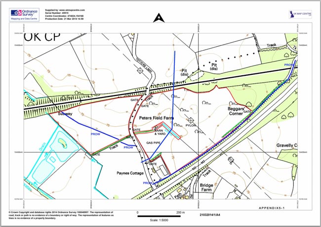
fields/parcels: 1318, 9019, 8602. The red lines in the illustration below indicate the boundaries of the east and west fields either side of Totters Lane. Much of the land is Grade 3 agricultural including inert landfill and to date the land has been used for grazing a dozen beef cows, a small flock of sheep and some horses. In the recent past the east field was used to dump rubble and hardcore following sand and gravel extraction. The north-east section of the site has been left in an untidy state with a single bank of earth rubble about 2 metres high and 20 metres long and numerous undulations of about ½ metre as marked in Appendix 1-4 which will be smoothed out under this proposal. Appendix 8-1 provides more information.
Site Boundaries
The site is bordered on the north side by the London to Southampton railway line and to the south by the M3 motorway. The north-east limit of the site is 83.28 metres above sea level with the lowest point at the south-west corner at 65.56 metres. The site slopes to the south with undulation – Topology Appendix 7. The north boundary bordering the railway is fenced, with scrubland on the railway side of the fence. The area to the north-east is woodland known as Beggars Corner. Four gates, three with wide turning areas on Totters Lane give access to the east field. Two wide gates give access to the west field south boundary via a hardened track. There is also access to the east field via Old Potbridge Lane to the north-east which joins the A30 at Phoenix Green. Old Potbridge Lane runs into a gated track at the border of Trimmers Farm which then runs to the east field via a
Public Right of Way (PRoW), footpath 501, and a substantial steel bridge over the railway. The boundaries with Totters Lane of both fields are hedges and drainage ditches.
The Equipment
The installation would consist of up to 1,670 strings of 24 x 250kWp solar photovoltaic panels mounted on metal frames for a duration of 25 years. At the end of the 25 year period the installation would be removed. The panel mounting structure would measure 0.5m above ground level at the front edge rising to 1.91m at the rear with panels mounted at an angle of 30° to the horizontal resulting in an overall row depth of 2.7m. Rows would be spaced by between 8.3 and 8.5m between centres resulting in a substantial grassed gap between each row of 5.6m. Each row would face due south. The mounting structure would comprise galvanised steel posts spaced at intervals depending on ground conditions. For the majority of the area the posts would be screwed and piled into the ground, see the engineering details in Appendix2-1. Where this would not be possible owing to buried rubble an alternative anchoring method would use concrete blocks measuring 40cm wide by 40cm high by 2m long sitting on a gravel base 10cm in depth. The nature of the buried rubble means that investigatory drilling would be of no benefit. Each pile would have to be tried individually and if found to be impractical would have to be substituted with a ballasted fixing.
Generating capacity would be up to 10 million Watts at a peak irradiance level of 1,000 Watts per square metre of incident sunlight. The solar panel layout plan makes allowance for maintenance access under a 110kV transmission line pylon in the centre of the east field and 3 metres either side of an electronically protected national grid gas pipe, with current monitoring connections at the north and south field boundaries, which runs north/south under the east field and under the railway. The top of the gas pipe within the field is 1.5 metres below ground level. The north end of the pipe runs under the railway, the south end under Totters Lane and then south under the motorway. The centre section of the pipe runs under the central drain emerging at the north side of the drain where it changes direction by approximately 30° before running north.
Deployment would require the installation of 10 prefabricated concrete inverter cabinets, 4 of which would be located in the west field plus a control cabin and a sub stations at the south-west corner of the east field containing the equipment to convert the electricity generated to be compatible with the grid connection. The cabins would be coloured dark green (RAL 6005). See Appendix1-5 for locations. The grid connection would be made to a 33kV connection T-point in an existing wayleave approximately 700 metres south of the site via a cable in a trench down Totters Lane.
To secure the site and protect the solar panel arrays from vandalism it is proposed, to erect minimally visually invasive green (RAL 6005) 3.0 metre panel width 2,330 mm high welded 200 mm x 55 mm open mesh fencing fixed at the base at approximately 50 mm above ground level. This would provide sufficient space for the entry and exit of small mammals with minimal impedance to flood and ground water movement. Supporting fence posts measuring 60 mm x 60 mm spaced at 3 metre intervals would be set into the ground to a depth of 500mm filled to not less than half the depth with concrete. The 3 metre spacing would allow larger mammals to burrow under the fence to maintain and preserve their runs.
A remotely monitored inward facing video security system activated by infra red sensors during the hours of darkness would be installed within the site boundaries. Camera locations are shown in Appendix2-1
The Ground
None of the boundary hedging would be removed. All existing hedging and public rights of way outside the boundary fences would be maintained as specified in Appendix 10. A root zone of at least 4 metres would be left between the boundary fences and the hedges. Upon completion of the electrical installation, sections of the site would be seeded with grass and wild flower mix using only local species, found within 30 km of the site, to conserve and enhance the local pollinator population, encourage biodiversity and provide cover for ground nesting birds, insects, lepidoptera and rodents. The site would continue to be used to graze sheep.
Visibility
The Trimmers Farm area is remote from residential areas being shielded by the local topography and is separated from the Bagwell Lane residential area by 1.5 kilometres of fields, hedges, woodland and the elevated M3 motorway. The only property bordering the development is Paynes Cottage. This property, with its manège to the rear, stands on a large plot at the south-west corner of the east field bordered by hedgerows and ditches. There would be matching appropriate hedging infill to obscure the view of the east field from the cottage. There are further properties on Totters Lane to the south which are separated and shielded from the proposed development by extensive vegetation and the M3 motorway which is elevated to approximately 15 metres. As far as we can tell without entering the properties there is no visibility from Potbridge Farm or properties in Poland Lane. There is no visibility at all from the properties north of the railway.